


GPS Maps Navigation GPS Camera
4.139.00 Reviews
App Specs
- Version
- 1.54
- Updated On
- License
- Free
- Downloads
- 100,000+
- Developer
- Galaxy Apps Center
- Categories
- Maps & Navigation
- Platform
- Android
Screenshots
 Analysis by AppCompare
I judge a navigation app less by how many buttons it offers than by whether it helps me make a calm decision when I’m already late, turned around, or trying to find a place I’ve never visited. GPS Maps Navigation GPS Camera has an appealing combination for that kind of trip: it is a maps and navigation app, with a camera element that ties photos to places. That mix may suit someone who wants directions and a travel record in one place, though I would not treat a broad feature pitch as a reason to abandon a navigation tool I already trust.
What to expect when opening it
The app comes from Galaxy Apps Center and is free to install, with in-app purchases listed from $1.99 to $8.99 per item. Its current release is version 1.51, and it is rated for Everyone. I’d think of the free download as a chance to see whether its approach fits your routine, rather than assuming every option is included at no cost. The store shows a 4.2 average from around 265 ratings, which is a useful snapshot of user sentiment, not a guarantee that it will behave the same on every phone or route.
On speed, the most useful question is not whether a map opens instantly in every situation, but whether the app keeps the next decision easy to find. A straightforward layout can help reduce fumbling before a drive, while route calculation and map display may still depend on the phone, GPS reception, and network conditions. I’d set a destination while parked, check that the route looks sensible, and only then begin moving. That small habit matters more than trying to judge responsiveness while driving.
When navigation gets demanding
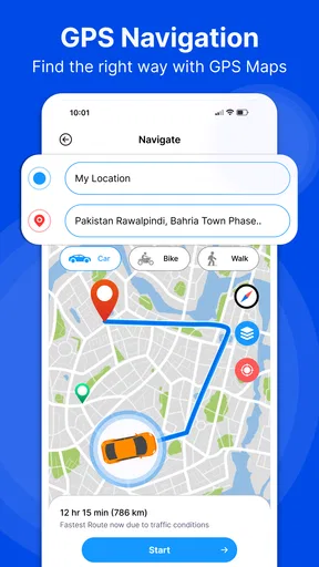
A short familiar commute is an easy test, but a more revealing one is a route with several turns, an unfamiliar destination, and a stop along the way. In that situation, I’d pay attention to whether instructions are understandable early enough to choose a lane or turn safely, and whether the screen remains legible without constant tapping. Voice guidance can be useful if it is available and working as expected, but I would keep the phone mounted securely and avoid interacting with it while the car is moving.
For a longer drive, I’d prepare before leaving: enter the destination, review the broad route, and make sure the phone has enough charge for navigation. If you are relying on a map away from dependable mobile coverage, check the app’s actual offline options before the trip rather than assuming all areas are ready to use without a connection. A route planned at home is also easier to reconsider than one entered at a roadside stop under pressure.
The camera angle gives the app a second kind of heavy-use moment. If you are stopping often to photograph a landmark, trailhead, or viewpoint, a location-linked image can make the trip easier to remember later than a gallery full of unlabeled pictures. I’d use it selectively: capture the places whose location will matter to you, rather than turning every stop into a documentation task. That keeps the camera useful without distracting from the outing itself.
Reliability and sensible checks
Navigation reliability is partly about software and partly about conditions no app can fix. Tall buildings, poor GPS reception, a low battery, or a weak data connection can complicate a route, so I would not rely on a phone as the only plan for a remote journey. Before setting off somewhere unfamiliar, check the destination and route, keep a backup way to orient yourself when the consequences of getting lost are serious, and pull over safely if the directions stop making sense.
Worth Reading Before You Choose

EA SPORTS FC Mobile 26 Is a Bigger Football Game, but It Takes Time

Flipboard Shows What News Apps Must Do Beyond the Feed

Switching to Android Auto Means Rethinking Your Driving Routine

Google Calendar Makes a Crowded Week Easier to Manage

Ludo King Makes the Most of the Minutes Between Plans

Baby Panda World Brings Quick Play to Modern Phones, but Its Game Library Feels Busy
The same caution applies to location-stamped photos. A timestamp or coordinate can help you remember where a picture was taken, but it is worth thinking before sharing an image that reveals where you are or where you live. I’d review a photo before posting it and share location details only when they are useful to the people receiving it. That is a practical trade-off of making travel photos more informative.
How it fits different phones and habits
The minimum operating-system requirement is version 10, so older devices may not be suitable. Even on a supported phone, maps, GPS, camera use, and screen-on navigation can all compete for battery and device resources. I would avoid starting a long drive with a nearly empty battery and would close unrelated tasks if the phone feels sluggish. Those are sensible precautions for any navigation app, not proof that this one is unusually demanding.
This is a particularly natural fit for someone who occasionally drives to new places and likes having trip photos tied to their locations. It may also appeal to travelers who want one app to explore for both route guidance and memory-keeping. If your daily use depends on highly detailed local transit planning, extensive route customization, or a familiar ecosystem of saved places, compare the app with the navigation service you already use before switching. Familiarity and local coverage can matter more than having extra functions in one app.
Getting Started with GPS Maps Navigation GPS Camera
The first thing I noticed when I downloaded GPS Maps Navigation GPS Camera was its user-friendly interface. It’s intuitive, even for those who might not be tech-savvy. Upon opening the app, you’re greeted with a clean layout, offering a seamless experience right from the get-go. Whether you’re setting up a route or snapping photos, everything is just a tap away.
Navigation Features That Stand Out
Let’s dive into the navigation features. This app isn’t just about getting you from point A to B. It’s like having a local guide who knows all the best shortcuts and hidden gems. The real-time traffic updates are incredibly accurate, helping you avoid those dreaded traffic jams. Plus, the voice-guided directions mean you can keep your eyes on the road, which is crucial for safety. I’ve tested it on a few long drives, and it’s like having a co-pilot who never gets tired.
Another standout feature is the app’s ability to work offline. You can download maps of specific areas beforehand, which is a lifesaver if you’re heading into zones with spotty internet coverage. No more worrying about losing your way because you’ve lost your signal!
Capturing Moments with GPS Camera
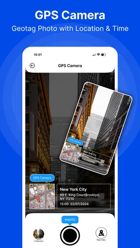
Now, onto the camera feature. This isn’t just your ordinary camera app. It’s designed to help you document your travels with precision. Every photo you take with the GPS Camera feature comes with embedded coordinates and a timestamp. Imagine snapping a stunning sunset photo and having all that info right there in the image. It’s like having a digital scrapbook of your adventures.
The camera interface is straightforward, allowing you to quickly adjust settings like exposure and focus. Whether you’re capturing a bustling cityscape or a tranquil mountain view, this app ensures your photos are not only beautiful but also informative.
Additional Perks Worth Mentioning
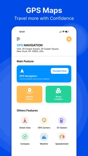
Beyond the core navigation and camera features, the app includes some neat extras. For instance, the integration with social media platforms makes it super easy to share your location-tagged photos directly with friends and family. It’s a great way to let everyone know exactly where you’ve been exploring.
The app also includes weather updates, which are handy for planning your day. Knowing if you need an umbrella or sunscreen before heading out can make all the difference in your travel experience.
Putting those features to work
A realistic use would be a weekend drive to a town you do not know. Before leaving, I’d enter the destination, glance over the route, and decide where I want to stop. Once parked at a viewpoint, I could take a location-tagged picture; later, the coordinates and time would help me identify the spot without trying to match it against a long sequence of similar landscape photos. The useful workflow is to separate driving from documenting: let directions guide the moving part, then use the camera when safely stopped.
For a practical test, I’d try a short route first, then check whether the destination was reached as expected and whether the saved photo carries the location details in a way that is useful to me. I’d also test any offline map preparation before depending on it in a place with poor coverage. A quick test at home or around town can reveal whether the app’s map behavior suits your phone, and it avoids discovering a setup issue when you are already far from familiar roads.
Trade-offs against familiar navigation choices
Many people already use a dedicated mapping app for directions and their phone’s built-in camera for pictures. That split can be perfectly sensible: a familiar map service may be preferable if you depend on its saved locations or established habits, while the standard camera may offer a workflow you already know. The appeal here is the combination of navigation and location-aware photography. It is most valuable when you actually want that connection between route and travel record, rather than merely because two functions appear in one app.
That distinction also helps answer whether it can replace a usual navigation app. I would not switch a whole household or rely on it for an important trip until I had compared routes on familiar journeys and checked how it handles the places I travel most. If your priority is simply getting to work on roads you know, a second navigation app may add little. If you regularly explore new places and want a clearer record of where you stopped, the combined idea has more practical value.
Keeping a trip smooth and safe
One non-obvious habit that helps with any phone-based route is to decide in advance what information you need from the screen. Set the destination and review the route while stopped; once underway, rely on spoken prompts where available and avoid searching for options at a junction. If a direction seems inconsistent with road signs or conditions, prioritize safe driving and stop somewhere appropriate before checking again. An app should assist judgment, not replace it.
There is also a small privacy decision built into location photography. If a picture is meant for a public post, consider whether exact coordinates add value or reveal more than you intended. A landscape photo shared with close friends may benefit from a location; a picture taken near home may not. Treating location details as something to choose deliberately makes the camera feature more useful and less automatic.
Who will get the most from it
I’d recommend trying it if you want a free starting point for everyday driving and like the idea of connecting travel photos with places. The app has reached over 100,000 installs, but that scale alone does not establish how well it will match your particular routes or device. Its Everyone age rating makes it broadly suitable from a content standpoint; the more important choice is whether the feature mix and any optional purchases suit your own needs.
I’d be more cautious if you need highly specialized navigation, depend on a particular set of saved locations, or often travel where a missed turn would create a serious problem. In those cases, compare it carefully with your current map app and verify the route before relying on it. The in-app purchase range is another reason to explore the free experience first and decide whether any paid options offer something you genuinely need.
Final Thoughts
Overall, GPS Maps Navigation GPS Camera is a robust tool for anyone who loves to travel or simply needs reliable navigation. It combines practicality with fun features, making it a must-have on your smartphone. Whether you’re an adventurer at heart or just need an efficient way to get around, this app has got you covered.
So, if you’re ready to enhance your navigation experience and document your journey like never before, give this app a try. You might just find it becomes your new favorite travel companion.
Pros
- Intuitive interface for easy navigation.
- Offline maps available for remote areas.
- Accurate real-time traffic updates.
- Customizable route options for efficiency.
- Integrated camera for geotagging photos.
Cons
- In-app ads can be distracting.
- Battery usage is quite high.
- Limited features in free version.
- Occasional GPS signal loss.
- May require frequent updates.
FAQs for GPS Maps Navigation GPS Camera
What features does the GPS Maps Navigation GPS Camera app offer?
The app combines navigation and camera functionalities, allowing users to capture photos with GPS coordinates overlaid. It includes turn-by-turn navigation, real-time traffic updates, and offline maps. Additionally, users can share their location-tagged images directly from the app, making it ideal for travelers and outdoor enthusiasts.
Is the GPS Maps Navigation GPS Camera app free to use?
The app offers a free version with basic features. However, to access premium functionalities such as offline maps, ad-free experience, and advanced navigation options, users can opt for in-app purchases or subscriptions. This flexibility allows users to try the app before deciding to invest in premium features.
How accurate is the GPS tracking in this app?
The GPS Maps Navigation GPS Camera app utilizes advanced GPS technology to provide highly accurate location tracking. However, GPS accuracy can be influenced by factors such as weather, terrain, and the device’s hardware capabilities. Generally, users can expect precise navigation and reliable location tagging, especially in open areas with good satellite visibility.
Can I use the app without an internet connection?
Yes, the app supports offline maps, which can be downloaded in advance for use without an internet connection. This feature is particularly useful for traveling in areas with limited connectivity. Users need to ensure they download the necessary map data beforehand to enjoy seamless navigation offline.
Is the app compatible with all Android and iOS devices?
The GPS Maps Navigation GPS Camera app is compatible with most modern Android and iOS devices. However, it requires a minimum operating system version for optimal performance. Users are advised to check the app store listing for specific compatibility requirements to ensure their device can support all features of the app.


